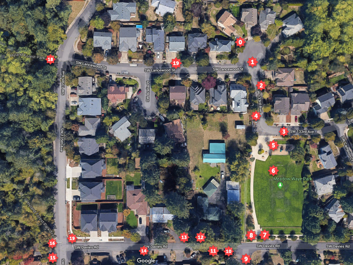
A proposed development may add a joining street between the intersection of SW 133rd and Bluebell and SW Davies Rd. This walk-around demonstrates traffic and flow in the neighborhood.
Neighbors would like to demonstrate the character of the neighborhood and roads that border the Meadow Waye Park area. This series of photos taken in October, 2019, depicts locations. You can match the locations on the top view to the photos in the walkaround. The proposed street as it exists today would connect to the corner of SW 133rd and SW Bluebell Lane and parallel the border of the park, connecting to SW Davies Rrd.
SW Bluebell Lane and SW 133rd Ave have sidewalks on both sides of the road, and the terminus at SW Davies Rd has a sidewalk to the east and a partially developed sidewalk to the west and described as a 46 foot right of way. The applicant Riverside Homes desires to install a 20 foot right of way road.
Given present conditions
- A new street should maintain the same sidewalk configuration and street width as the connecting streets to maintain consistency with the rest of the neighborhood and both foot and vehicle traffic
- A new street should not create new complex traffic intersections that could impact access and increase danger to park visitors
- A new street should maintain the level of safety of access for firetrucks, waste management vehicles and other large vehicles as with neighboring streets
- A new street should allow for street parking (and still allow through traffic) to allow for visitors to new homes without displacing neighbors or parking at the park
If the new road is developed, it should conform to the lesser of standards of width of SW Bluebell Lane and SW 133rd Ave to fulfill all points of flow through of traffic, parking and safety.
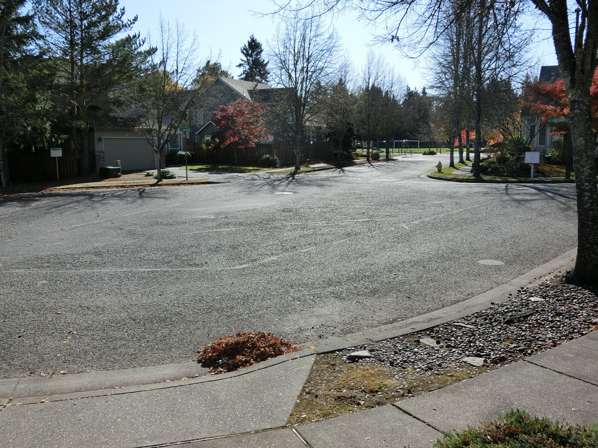
Starting (0) looking south | south east from a cul-de-sac down towards Meadow Way Park. Notice complete sidewalks with greenery verge (the area between the sidewalk and the street) and fire hydrant on the north-east corner of SW Lancewood Street and 133rd Ave. SW 133rd Ave is not a perfect north-south street here.
Now moving (01) south | south east from intersection of SW Lancewood Street and 133rd Ave and looking south | south east SW 133rd Ave. You can see the only dedicated parking for the park: two handicapped accessible spots.

Next, moving south | south east (02) along the east sidewalk of SW 133rd looking towards the intersection of SW Bluebell Lane and SW 133rd Ave. A direct line from SW 133rd Ave south leads directly to the handicapped parking for Meadow Waye Park. Note the continuous verge and sidewalk. The short stone wall indicates the property border.
The City of Beaverton clearly wanted to ensure safety at this intersection given the street sign indicating the 90 degree left turn.

Looking west (03) on SW Bluebell Lane towards the intersection of SW Bluebell Lane and SW 133rd Ave. Notice the near 90 degree angle of the intersection that is within proximity of a small children's playground.
A critical feature of the property is that previously a standing pond was located near the wooden fence on the right side (north side) of the photo, and that long time residents recall the developer of the homes along the south side of SW Lancewood Street buried a long French drain. Some neighbors are concerned that building close to the shared fence will exacerbate existing drainage problems on their properties.
An extension here of an irregular new street creates a very complex intersection and potentially dangerous for the pedestrians and small children that regularly use the park.

A closer view (04) looking south | south east on west sidewalk of SW 133rd Ave at the intersection of SW 133rd Ave and SW Bluebell Lane. The short wooden fence marks the edge of the park and the private property.
 looking south | south east on west sidewalk of 133rd at the intersection of 133rd and SW Bluebell Street")
A view (05) looking west from the north lawn of Meadow Waye Park towards the private property. The very large tree is on the private property and likely be cut down by the developer for the proposed street.

A view (06) from the southern part of Meadow Waye Park looking west towards the private property where the park footpath meets the sidewalk on the north side of SW Davies Rd. The two large fir trees likely to be removed to accommodate any street paralleling the development.

A view looking east (07) of the sidewalk along the north side of SW Davies Rd which intersects the south | southeast pathway through the park itself. The sidewalk curves slightly along the southern wood fence and continues.
 of the sidewalk along the north side of SW Davies Rd which intersects the south | southeast pathway through the park itself")
A view looking west (08) of the sidewalk along the north side of SW Davies Rd which intersects the south | southeast pathway through the park itself. Note the unpainted wooden fence marking the edge of public property.
A modest cut out provides limited parking (along with two on site parking spots to the north, and approximate space for three additional cars on the north). Even small events such as children soccer matches results in all parking spaces along this area and the northern parking spots to be filled by vehicles.
 of the sidewalk along the north side of SW Davies Rd which intersects the south | southeast pathway through the park itself")
A view (09) looking north | northwest from SW 133rd and SW Davies Rd and depicting the end of the sidewalk along the north side of SW Davies Rd. Both sides of this portion of SW 133rd have sidewalks on both sides and verge.
 looking north | northwest from 133rd and Davies Rd and depicting the end of the sidewalk along the north side of Davies Rd")
A view (10) looking west along the south side of SW Davies Rd. No sidewalk exists along the south side of SW Davies Rd. Sections of the north side have sidewalks that could be joined to improve foot traffic.
 looking west along the south side of SW Davies Rd. No sidewalk exists along the south side of SW Davies Rd.")
A view (11) looking north from the south side of SW Davies Rd towards the private property considered for development.
 looking north from the south side of SW Davies Rd towards the private property considered for development.")
A view (12) looking east from the north side of SW Davies Rd along the south side of the private property considered for development. Beyond the white gate note the parallel direction of the existing sidewalk along Meadow Waye Park.
If a joining lane ends here and the lane is not wide enough to accommodate large vehicles, then waste and recycling pick up could require cans to be located on either SW Davies Rd or along SW Bluebell Lane.
 looking east from the north side of SW Davies Rd along the south side of the private property considered for development.")
A view (13) looking west towards the north side of SW Davies Rd towards the intersection with SW 135th Ave and the sidewalk along both SW Davies Rd and SW 135th Ave that matches the development style of sidewalk added along the south side of Meadow Waye Park.
 looking west towards the north side of SW Davies Rd towards the intersection with 135th Street and the sidewalk.")
A view (14) looking west towards the intersection of SW Davies Rd and 135th Ave. Depicted is another fire hydrant.
 looking west towards the intersection of SW Davies Rd and 135th Street.")
A view (15) looking north east from the west side of SW 135th Ave towards the intersection of SW Davies Rd and SW 135th Ave. Neighbors to the east of these tall homes now have no privacy in their backyards. Because of drainage issues in the area, the properties had to have special development because of the impact of water flow.
 looking north east from the west side of 135th towards the intersection of SW Davies Rd and 135th Street.")
An alternative view (16) looking north east from the west side of SW 135th towards the intersection of SW Davies Rd and SW 135th Ave, noting complete sidewalks on both the west and east sides of SW 135th Ave.
 looking north east from the west side of 135th towards the intersection of SW Davies Rd and 135th Street")
A view (17) looking east from the north side of the intersection of SW Davies Rd and SW 135th Ave, noting the character of the sidewalk added with the development that was completed at the intersection in 2018-2019.
 looking east from the north side of the intersection of SW Davies Rd and 135th Street, noting the character of the sidewalk added with the development that was completed at the intersection in 2018-2019.")
A view (18) looking east from Highland Park on the west side of the intersection of SW Lancewood Street and SW 135th Ave, noting mature sidewalks and verge along the east side and sidewalk paralleling Highland Park.
 looking east from Highland Park on the west side of the intersection of SW Lancewood Street and 135th Street")
A final view (19) looking east from the north side of SW Lancewood Street towards the culdesac of SW Lancewood Street and SW 133rd Ave (0).
 looking east from the north side of Lancewood Street towards the culdesac of Lancewood Street and 133rd (0).")
This brings us back to the beginning where photo (0) was taken.